Summit launch Template page
Currentlty this site is Closed.
Please respect the Landowner by not using it until further notice
Pine Mountain Rock L
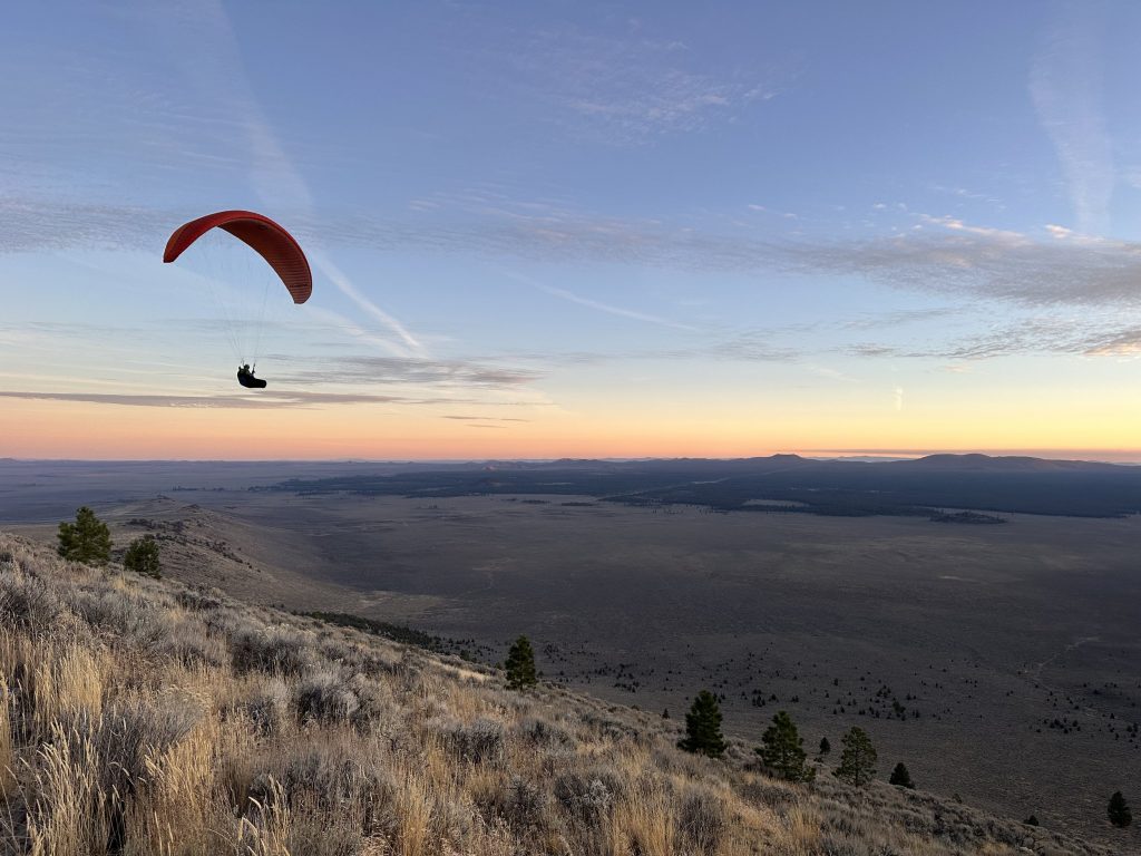
Lopcated 28 Miles east of Bend, OR. This “Front side” Pine Mountain site sits at 4900′ in the Millican Valley. Sunset flights her with views of the Tree Sisters Mountains are dreamy. This site is known for great ridge soareing and glass-off evening flights. with a summit reaching 6400′ behind the launch, you can bench up very high during soaring conditions and glass-off.
Site Rating
P-2 Required
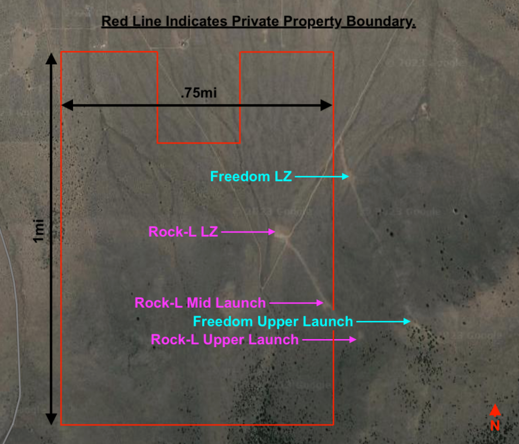
LZ Coordinates
Mid Launch
Upper Launch
Max Wind Speed
15 MPH
Min Wind Speed
5 MPH
Max Gust Factor
5 MPH
Ideal Wind Direction
303.75 – 326.25 NW
“USHPA & Local Club Membership Required” Main Radio Frequency 151.505
How to Get Here
Take HWY 20 east to Millican, OR. You will take the first right after the old abandoned gas station. The turn is located here. 43.844242, -120.930622. Then follow the dirt road south for 2.6 mi towards the Pine Mountain to the “Y” located here 43.844242, -120.910623 . You will take a sharp right hand turn here and follow the dirt road down and to the west for half a mile to the “T”. Located here 43.848267, -120.922232 . From here you will take a left and head south again up the hill for just under a mile to the parking area and main LZ. 43.837310, -120.930622 .
When you enter the private property there is a speed limit posted. Be respectful to the land owner and obey any posted signs. Once at the parking area, park along the rock wall. As the north side of the parking area is the main LZ. There is a north entrance to the site as well. This passes through the neighborhood of cabis below the site. They maintain their own roads at their own costs. So if possible it’s courteous not to use this route unles you live there. The site is gated. contat the Desert Air Riders to gain site Access
Note: The road is a bit rough but is passable in smaller cars like subarus. The area sees a lot of use by pilots. Be a good steward & respectful to the area.
Launch and Land
Mid and Upper Launch
Mid- 43°50’04.3″N 120°55’41.5″W
Upper Launch- 43°49’59.8″N 120°55’34.7″W
Once at the parking area you will see a large pea gravel area. Directly across the dirt road from the pea gravel to the east, is a well aorn in trail that heads up the hill. Many locals will set up at the pea gravel and kte their wings up this trail. In stronger conditions (10mph+) you don’t have to kite or hike very high up the hill before you are able to launch. However below 10mph most pilots use the mid and upper launches. mid launch is halfway between the parking lot and the top of the ridge. There is a small juniper tree with a wind sock in it and a abench below. The launch is clear of major obstacles but there are still small desrt plants and some rock that can and does catch lines. So be aware of any snags when laying out and launching.
If you continue hiking or kiting through the mid launch, you will find another trail towards the NE corner of the cleared area of the mid launch. This trail is much tighter than the lwer section and lined with larger sage bushes. It meanders further up the hill to the upper Launch clearing. This launch sits in front of th trees and just below the top of the ridge. There is a large rock stack with a wind sock pole at the uper end of ther clearing. This launch is ver similar to the mid launch just further up the hill.
Both launches face NW and the hill in general is free of obstacles. Launching is pretty straight forward. But be aware of punchy thermals gusting up the hill earlier in the day when the thermals are still letting off. They can be very strong. A good tip here is feeling steady wind. if the wind seems to be ramping up and down and switching directions often. It is likely still thermic
5-15 MPH wind speeds are listed above as a general guideline. But many pilots launch in conditions ranging from 0mph-20mph+ here. Glide from mid and upper to the parking area LZ is achieveable in nil wind even on smaller wings easily. May of the locals are extremely skilled especially at their home site and fly very high performance wings. Be aware of this during strong conditions. They ofthen make the conditions look safe and easy. When in reality they are extremely challenging.
Landing Zone “LZ”
Most pilots like to land at the parking area. It is a down slop landing. That takes a specific landing pattern to pull off well. Again the locals make it look easy. But take your first landing with caution. The most common pattern (when the wind is NW) is to set up your base leg along the bottom of the ridge to the NE. Working your way cross wind back up hill towards the bowl of large pine trees below the true summit of the Mountain. When lined up with the LZ turn back into the wind for your final and come in for your landing. this LZ is slanted downhill and falls away from you as you come in for final. Often many pilots start gaining altitude again on final and fly far down the hill towards the cabins in the endless desert sage. There are not many trees and the area is pretty wide open for the most part. So over shot landings are normally no mare than a frustrating fight with your lines in the sgae and a short hike back up.
The desert is pretty wide open and landings are possible almost anywhere. But the other main LZ for this site is located at the “T”. 43.848267, -120.922232 . If you miss the LZ at the parking area, chances are you are too low to make the “T”. But if you are high (upper launch or higher) and don’t want to use the main LZ. It’s a far walk back so make sure you plan ahead and have a car or retrieve driver.
Note: Most accidents in Central Oregon are due to strong wind and/or underestimating the wind strength. Know your capabilities & wing loading before launching.
Site intros:
For a site intro, hit up the local chat and connect with a local
Flying the Rock-L
The Rock-L site is primarily mechanical lift ridge soaring site and can be flown year round with NW wind around 5MPH-15MPH. In the warmer months ridge soaring is often combinded with thermals and world class glass-off conditions. The glass off conditions here can cause bouyant air throughout the area for many miles in all directions. Where it commonly requires pilots to use descent techniques to even get down. It can prove very hard to get down for novice pilots.
After launching make sure to stay out front at first and check your penetration before working your way up and back into the stronger lift band. People have been blown back here recently.
The main ridge near the launches can get pretty crowded on good nights. With many gliders in the lift band it is important to keep your head on a swivel looking out for other gliders and use the standard “Rules of the Ridge” to avoid collisions. Also a few Schools operate in the area and ther are students present most nights.
The NW wind will come into both the ridge and the large bowl to the south of the main launches. It is popular to get up on the ridge and work your way back in to the bowl to bench up to the summit. Note that the bowl can create a venturi effect making it hard to get back out over the open desert once you enter the bowl. So ease in and turn back towards the LZ often to check penetration as you work your height, there can be no escape from the bowl if you get pinned back in there low.
During good glass-off conditions in the evenings. Pilots will work up way above the 6400′ ft summit and fly out over the Millican Valley in all directions for miles. The sunset views over the Three Sisters to the West during Glass-off are all time.
Hazards, Notes, & Rules
Be aware of changing conditions and wind gradients.
The Millican Valley is full of small cabins and private properties. Some of these in the past were known LZs. All are now CLOSED to the Public. One is owned by a local school and many others are owned by local pilots. So if you see others landing there, it does not mean you can.
This site is on private land and is managed by a local club. The Desert Air Riders or DAR. They maintain the site, pay for wind socks, and cover the costs of insurance by the land owner. You can contact them at desertairriders@hotmail.com or visit www.desertairriders.org for more information.
Please respect all signs and rules. Some of the major ones are:
- No Commercial operations ( Tandems for hire or paid instruction)
- Dogs must be on a leash
- No Smoking/ Vaping
- Current USHPA P-2 or higher
- Local Club Membership “encouraged”
- No Fires or BBQs
- No Hang Gliding or Speed Flying or PPG
- No Drones
For Emergencies call 911 or Activate your S.O.S. personal locator
Currently this site is closed.
Please respect the landowner by not using it until further notice
Disclaimer & Terms of Use
Last updated on May 26, 2023
The information provided by the Central Oregon Hang Gliding and Paragliding Association on Desertairriders.org is for general purposes only. Should you choose to read and use any information provided, do so at your own risk. Prior to setting out check current weather, conditions, and land/road closures. While flying, obey all public and private land use restrictions and rules, carry proper safety and navigation equipment. The information found herein is simply a planning resource to be used as a point of inspiration in conjuction with your own due-diligence. All information on the Site is provided in good faith, however we make no representation or warranty of any kind, express or implied, regarding the accuracy, adequacy, validity, reliability, availibility, or completeness of any information on the Site.
UNDER NO CIRCUMSTANCES SHALL WE HAVE ANY LIABILITY TO YOU FOR ANY LOSS OR DAMAGE OF ANY KIND INCURRED AS A RESULT OF THE USE OF THE SITE OR RELIANCE ON ANY INFORMATION PROVIDED ON THE SITE. YOUR USE OF THE SITE AND YOUR RELIANCE ON ANY INFORMATION ON THE SITE IS SOLEY AT YOUR OWN RISK.