The Rock L
Originally submitted by Pete Keane, 2002
Last Updated 6/19/2023 By Jennifer Cohoon
Pine Mountain – North Side – Rock L – is located in the “High Desert”, 26 miles east of Bend. With an altitude 6407′, ideal climate. Its desert thermal conditions and ridge soaring is a formula for excellent paragliding. Depending on the amount of snow, it can be flown all year. Extreme caution should be taken when flying “Pine” during the summer — it is a desert thermal site and flying midday can be extremely hazardous to your health.
Risk Mitigation / Wind Information / Glide Ratio
- Min USHPA Rating P2
- Min Wind Speed 0 mph
- Ideal Wind Speed 10 mph
- Max Wind Speed 15 mph
- Maximum gust factor 5 mph
- Wind Direction Ideal 310º – 360º
- Wind Direction “OK” 280º – 20º
- Min Required Glide Ratio 3.6
- Click here to read the full Risk Assessment for Pine Mountain/Rock L
Related documents
- Google Map of commonly used locations around Pine Mountain
- Pine Mountain Strong Wind Glass-off Techniques
- Pine Mountain Fly-in Info
State Distance Records
Since Pete Keane wrote this site guide in 2002 the Oregon paragliding distance record has been broken six times from Pine Mountain with 100+ mile flights.
- 7/2/2004 Jeff Huey 111 miles (story)
- 7/15/2008 Brian Webb 136 miles (story)
- 7/15/2015 Jared Anderson 145.8 miles (story)
- 8/13/2016 Matt Henzi 176.2 miles (tracklog)
- 6/21/2018 Matt Henzi 181.8 miles (tracklog)
- 6/29/2018 Reavis Sutphin-Gray 198 miles (tracklog)
Camping Options
The Forest Service’s Pine Mountain Campground, on top of the mountain near the observatory, has six campsites available on a first-come-first-served basis. It’s a dry campground so bring your own water.
Regarding camping at the base of the mountain: The Rock L landowner says, “I would ask campers to stay at the Y, and to use the Rock L for parking and landing only.”
FRONT SIDE (north side)

The front side of Pine Mountain is a combination of public and private land. The area we refer to as the Mid Launch and Rock L, and the associated access road, is private land with important posted rules.
- Current USHPA Membership required. P2 or higher rating.
- Paragliding only; no hang gliding or powered paragliding
- Recreational flying only; no commercial (paid) instruction
- Dogs on leash at all times
- No smoking, open fires, or BBQs; E-cigarettes/vaping permitted
- No motorized vehicles allowed off road
- No drones allowed
- Speed limit on private property: 10 MPH
- Parking: Please only park along the Rock L, starting west of the pea gravel
- Only those willing to follow rules and represent landowner’s interests are welcome (see 1-9 above)
Land bordering this private land to the south and east is USFS and BLM. Land bordering to the west and north is also private. Access to Mid Launch and Rock L is only allowed when the rules are followed. If you are on the property and not following the rules, you are trespassing. Contact hellodesertairriders@gmail.com if you have any questions about the rules.
*Note On Landing / LZ Areas
The following LZ’s were used in the past. Due to new land ownership and or other circumstances. They are NO LONGER VIABLE LZ’S. DO NOT LAND THERE WITHOUT DIRECT PERMISSION FROM OWNER
- Harrison Ruffin (previously Wrights Place or Wrights) LZ (43.845224 120.936535)
- Flying Farm Landing Zone (43.84529 120.94483)
- Gorbett LZ (43.8483 120.9309)
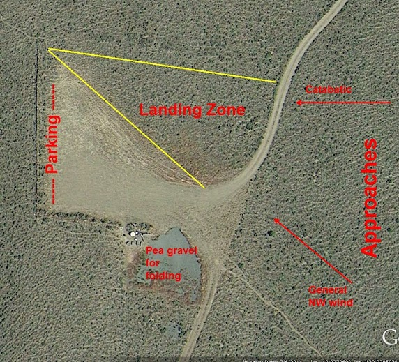
Using the Rock L parking and landing area
There are three separate areas in and around the Rock L.
- Pea gravel: Primarily intended for folding gliders, but it’s okay to land in the pea gravel if it’s mostly open (not covered with gliders) and if you can do it safely. If pilots are still flying and landing, any gliders in the pea gravel shouldn’t be left spread out for extended periods of time, they should be folded up or moved to the side.
- Parking: Inside the “L” along the rock wall.
- Landing zone: Cleared area north of the “L” and west of the road. The boundary between the parking and the landing zone is marked with orange traffic cones.
Directions to the Mid Launch and Rock L area
At Millican, take a right on the road, which is marked as the way to the Pine Mountain Observatory. Drive to the “Y”, which is a couple of miles in from Hwy 20. This is the first major right turn that you will come to. Follow this rocky road for less than a mile, take the first left turn, which heads up towards the mountain. Eventually, you’ll come to the Rock “L” parking area. This is the preferred LZ*. From the parking area look across the road and you’ll see a trail leading up to two cleared launch areas — the mid launch is at 5000′ and the upper launch is at 5200′.
Using the Mid Launch (aka “The Training Hill”) & Upper Launch
The Mid Launch on the Training Hill & Upper Launch are most commonly used during the evening hours and most folks arrive sometime during the last 2-3 hours before sunset. Most often, this site is good for evening flying, when it is blown out during the day. So most people arrive, hike up the hill (10-20 min) and wait for the air to smooth out. Less commonly, but typically in the spring and fall on light wind days, the glass off builds and the best flying comes near the end of the day, when the desert releases its heat. This launch faces NW, so look for N, W or NW winds on the surface as good indicators that the evening session might happen. On good nights, a couple good hours of flight can be had and it is commonly possible to bench up to the summit. Ideal wind direction is 310-360?.
Pine Mountain Flying Guidelines
Guidelines:
1. Respect Millican Valley landowners and avoid landing on private land.
2. Be aware of stock and wildlife. Leave space between you and wild or domestic animals when launching, landing, and flying.
Suggested flight plan from the top of Pine is very similar to the hang gliders search pattern:
1. Launch from the paragliding launches instead of the hang launch, especially when there is any northern component to the wind or cycles. This will give you a little extra altitude to get around the corner below the peak of Pine.
2. If you can’t find a thermal to sustain or climb out over the top of Pine using the west face or the northwest rock spine, work your way down the training hill spine. If you get low on the west face it would be best to side hill land and hike back up.
3. If you sink out using this search pattern you can easily land at the Rock “L” landing zone or anywhere in that area leading to the “T” landing zone that the hang gliders use.
Some hints for flying glass-off from the training hill:
1. Be extra careful of your penetration when benching up. You should plan on crabbing towards the Y if conditions strengthen to avoid blowing over the ridge.
2. Turn right after launch and work the East spine until you are even with the top of the ridge. Then cut over the upper launch to the pines at the top of the ridge. From there, check strength and work back into the canyon below the tall pines. Turn N, check again and then make a final turn up to the trees. If the conditions have an east component (NE), work the opposite side of the canyon below the spine.
3. Read Frankie and Phil’s article Pine Mountain Strong Wind Glass-off Techniques.
© 2023 Desert Air Riders