Freedom Launch
Freedom Launch
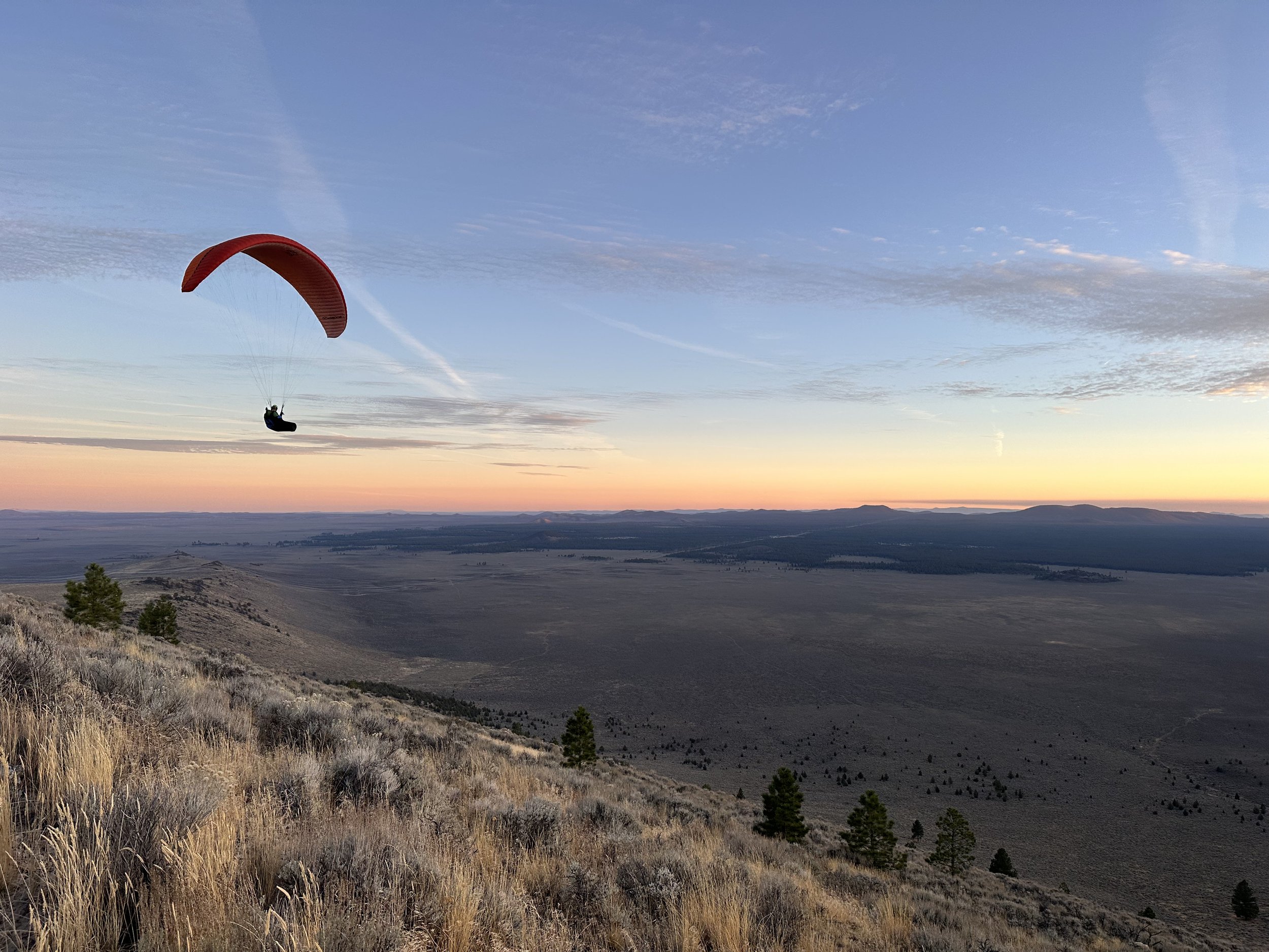
Freedom is located just north on the same ridge as the Rock-L site. Another “front-side” Pine Mountain site that sits at 4700′ in the Millican Valley. Sunset flights here with views of the Three Sisters mountains are dreamy. This site is known for great ridge soaring and glass-off evening flights. With a summit reaching 6400′ behind the launch, you can bench up very high during soaring conditions and glass-off
Site Stats
Site Rating
P-2 “Suggested”
LZ Coordinates
Mid Launch
Upper Launch
Max Wind Speed
15 MPH
Min Wind Speed
5 MPH
Max Gust Factor
5 MPH
Ideal Wind Direction
303.75 – 326.25 NW
How to Get There
Take Hwy 20 east to Millican, OR. You will take the first right after the old abandonded gas station. The turn is located here 43.878310, -120.916497 . Then follow the dirt road south for 2.6 mi towards Pine Mountain to the “Y” located here 43.844242, -120.910623 . You will then take a sharp right hand turn here and follow the dirt road down and to the west for half a mile to the “T”. Located here 43.848267, -120.922232 . From here you will take a left and head south again up the hill for just under a mile to the parking area and main LZ just off the road to the left. 43.839666, -120.926853 . The turn off for the parking area is just before the gate to the private property flying site known as the “Rock-L”. Once at the parking area, park along the NE edge of the clearing and west of the table and sitting area. As the south side of the parking area is the main LZ.
Note: The Road is a bit rough but is passable in smaller cars like subarus. The area sees a lot of use by pilots. Be a good steward & respectful to the area.
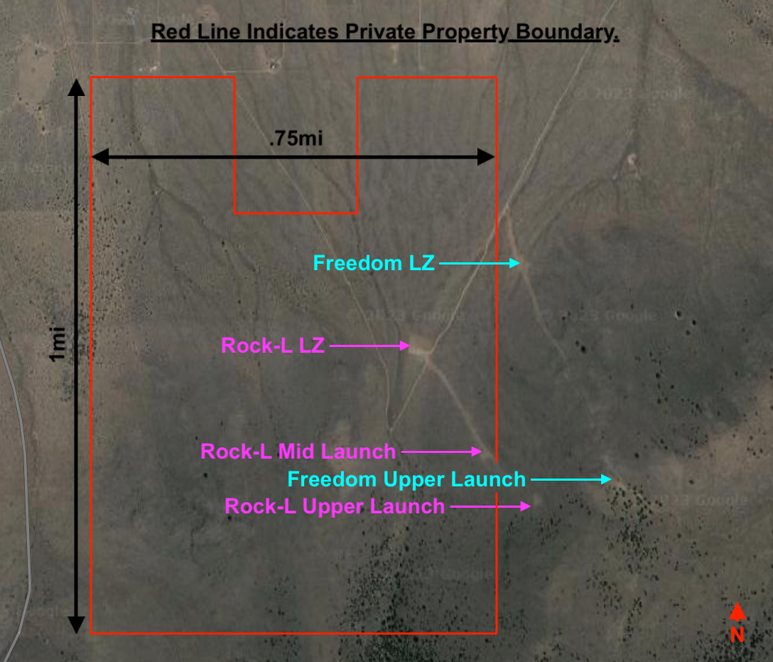
Mid and Upper Launch
Mid launch- 43°50’12.0″N 120°55’30.8″W
Upper Launch- 43°50’03.7″N 120°55’25.2″W
From the parking area a faint trail heads east driectly pu the ridge. Following the line of 4 wind socks that lead up the hill. Pilots will kite and or hike up this trail to launch. Pilots kiting will only go up as high as needed to launch, given the day’s conditions. Hikers have two main options, Mid and Upper Launch. The Launches are fairly undeveloped and the launch survace is a mix of rock and grass. with the occasional small shrub. Care should be take when laying out and launching. The surrounding areas have a lot of sage and other obstacles that make it very hard to lay out and launch
Both launches face NW and the hill is generally free of larger obstacles. There are a few trees but they are sparse and easy to avoid. Launching is pretty straight forward. But be aware of punch thermals gusting up the hill earlier in the day when thermals are still letting off. They can be very strong. A good tip here is fgeeling steady wind. If the wind seems to be ramping up and down and switching directions often. It is likely still thermic and caution should be used. Another good tip is, if you see dust devils out in the Millican Valley it is liekly still thermic. Upper launch her is often used by the various local paragliding schools. So be attentive to students at the launch and in the air.
5-15 MPH wind speeds out of the NW are listed above as a general guideline as they work the best. But many local pilotys launch in conditions ranging from 0mph to 20mph+ here in any wind direction from West to true North. If you are visiting or new, talk to a local and play it safe by following the suggested parameters before trying more varied conditions.
Glide from mid and upper to the parking area LZ is achievable in nil wind even on smaller wings easily.
Many of the locals are extremely skilled, especially at their home site and fly very high performance wings. Be aware of this during strong conditions. They often mak the conditions look safe and easy. When in reality they are extremely challenging.
Landing Zone “LZ”
Most local pilots like to land at the parking area. It is a tricky cross slope landing. Depending on how many cars are parked, it can also be a bit tight. It takes a specific landing pattern to pull off well. Again the locals make it look easy. Take your first landing with caution. The most common pattern is to set up your base leg along the bottom of the ridge to the NE or SW depending on the wind. Working your way cross wind along the bottom of the ridge and turning into the wind for your final, once close to the LZ. The base leg here can ber quite long. with final being only a few hundred feet. This LZ is NOT FLAT. And depending on your approach it can be slanted downhill, falling away from you, side hill, or uphill as you come in for final. Many pilots over shoot the LZ and land in the sage between the LZ and the dirt road. There are not many trees and the area is pretty wide open for the ost part. So over shot landings are normally no more than a frustrating fight with your lines in the sage and a short hike back up. The main LZ also sits slightly behind and below a gentle knoll to the west. This “can” cause some dirty air / light rotor down low just above the LZ. But not always. So be aware of this when landing. Pressurizing our glider with a little brake pressure can be helpful in this situation.
The desert is pretty open and landing are possible almost anywhere. The other main LZ for the site is located at the “T” 43.848267, -120.922232 . If you miss the LZ at the parking area, chances are you are too low to make the “T”. But if you are high (upper launch or higher) and don’t want to use the main LZ this is an easy glide Many novice and student pilots use this LZ. It’s a far walk back so make sure you plan ahead and havea car or retrieve driver.
Note: Most accidents in Central Oregon are due to strong wind and/or underestimating the wind strength. Know your capabilities & wing loading before launching.
Site intros:
For site intros, hit up and connect with a local on the telegram chat
Flying Freedom
The Freedom site is primarily a mechanical lift ridge soaring site and can be flown year-round with NW wind around 5mph-15mph. In the warmer months ridge soaring is often combined with thermals and world class glass-off conditions. The Glass-off conditions here can cause bouyant air throughout the area for many miles in all directions. Where it commonly requires pilots to use descent techniques to even get down. It can prove to be very hard to get down for novice pilots.
After launching make sure to stay out in front at first and chek your penetration before working your way up and back into the stronger lift band. People have been blown over the back here recently.
The main ridge near the launches can get pretty crowded on good nights. With many gliders in the lift band it is important to keep your head on a swivel looking out for other gliders and use the standard “Rules of the Ridge” to avoid collisions. Also a few Schools operate in the area and thera rea students present most nights.
The NW wind will come into both the ridge and the large bowl to the south of the main launches. It is popular to get up on the ridge and work you way back in to the bowl and bench up to the summit. Note that the bowl can create a venturi effect, making it hard to get back out over the open desert once you enter the bowl. So ease in and turn back towards the LZ often to check penetration as you work your way up and back deeper into the bowl pocket. Depending on your height, there can be no escape from the bowl if you get pinned back in there low.
During good glass-off conditions in the evenings. Pilots will work up way abvoe the 6400’ft summit and fly out over the Millican Valley in all directions for miles. The sunset views over the Three Sisters to the west during glass-off are all time.
Hazards, Notes, & Rules
Be aware of changing conditions and wind gradients. The Millican Valley is full of small cabins and private properties. Some of these in the past were known LZs. All are now CLOSED TO THE PUBLIC. One is owned by a local school and many others are owned by local pilots. So if you see others landing there, it DOES NOT mean you can land there.
The Rock-L site just up the hill is a USHPA regulated site on private land, and managed by the local club (Desert Air Riders) Freedom was built by local pilots over the years that were not USHPA or Club Members. As means to fly the ridge without regulation. Both USHPA/club and not rated pilots fly together at Freedom. Only USHPA/Club members can fly at the Rock-L
Currently the Rock-L is CLOSED. Please respect the club, landowner, Gates & Signs. Contact DesertAirRiders@hotmail.com for more information.
Disclaimer & Terms of Use
Last updated on May 26, 2023
The information provided by the Central Oregon Hang Gliding and Paragliding Association on Desertairriders.org is for general purposes only. Should you choose to read and use any information provided, do so at your own risk. Prior to setting out check current weather, conditions, and land/road closures. While flying, obey all public and private land use restrictions and rules, carry proper safety and navigation equipment. The information found herein is simply a planning resource to be used as a point of inspiration in conjuction with your own due-diligence. All information on the Site is provided in good faith, however we make no representation or warranty of any kind, express or implied, regarding the accuracy, adequacy, validity, reliability, availibility, or completeness of any information on the Site.
UNDER NO CIRCUMSTANCES SHALL WE HAVE ANY LIABILITY TO YOU FOR ANY LOSS OR DAMAGE OF ANY KIND INCURRED AS A RESULT OF THE USE OF THE SITE OR RELIANCE ON ANY INFORMATION PROVIDED ON THE SITE. YOUR USE OF THE SITE AND YOUR RELIANCE ON ANY INFORMATION ON THE SITE IS SOLEY AT YOUR OWN RISK.